Mar 14, 2020 Travel
Many Te Araroa trail hikers bypass Auckland. Not Katrina Megget, who on foot rediscovered the contrasting personalities of her old hometown.
This story originally appeared on Noted.co.nz and has been republished with permission.
The sun dances on Mangere Inlet, a glittering jig in the distance. Native birds sing from the treetops, almost-tropical flowers pop in pink, yellow and red. Purple wisteria drapes itself over verandahs.
Auckland on a summer day – it’s hard to beat. I’m just not sure exactly what part of Auckland I’m in.
“Is this Mangere?” I ask my friend and walking companion. We’re well south of the CBD, in a leafy suburb surrounded by quaint Victorian villas with freshly painted, white-picket fences and groomed front gardens.
Have we taken a wrong turn? As two South Auckland girls who were raised in Papakura, we’re slightly flummoxed. The blue GPS dot on my phone screen throbs insistently, informing us that this is Onehunga. It just isn’t the Onehunga of our childhood memories.
But that’s the beauty of this sprawling city: there are so many different facets to its personality.
“I can’t believe the Te Araroa trail is right here under my nose in Auckland,” my friend had noted earlier, as we dodged the business suits on our stroll south from the downtown ferry terminal towards Manukau Harbour, on the 14km Coast to Coast Walkway stretch of the trail. “Unless you knew to look for it, you’d never know it was there.”
-mangere.jpg)
It takes about three days and 85km to walk New Zealand’s largest city from Long Bay on the North Shore to Drury in the south. Along the way, there are coastal paths that meander through suburbs of multi million-dollar houses, semi-rural sanctuaries, volcanic cones and a mash-up of New World heritage and modern architecture that spans the syringe-like Sky Tower to the crisp green and white of Auckland Domain’s Victorian-era cricket pavilion. “A district of contrasts,” is how the trail website sums up the Auckland leg.
Still, most of the Te Araroa trampers I met were bypassing the Auckland isthmus altogether, because those “contrasts” include a fair amount of pounding the pavement through city fringe and suburbia. Boring, they said. With 3000km of trail to discover, from Cape Reinga to Bluff, who needs to linger in Auckland’s urban sprawl?
Well, I do. For a Kiwi girl who grew up in the city and now lives in London, it’s a thrill to scramble up Devonport’s North Head and admire the gleaming cityscape after hiking more than 550km from the trail’s northernmost point.
Walking through a well-heeled North Shore suburb at dusk in December, I entertain myself by peering into full-length windows and comparing the height and ornamental opulence of the Christmas trees. I happily brave petrol fumes at the Royal Oak roundabout to reacquaint myself with burger and ice cream joint Ollies – a popular haunt from my teenage years. I even jostle with tourists on the 196m summit of Maungawhau-Mt Eden for the mandatory snap of Auckland’s spread of grey and terracotta rooftops, outcrops of high-rises, the curves of Rangitoto Island and the lone obelisk atop Maungakiekie.

“I used to come up here on Friday nights with my boyfriend from university and ‘watch the city lights’. We’d sit in our steamed-up car like everyone else,” I tell my friend. “Can’t do that now with the vehicle ban.”
The good old days? Maybe, but closing five of the city’s summits to vehicles has made them safer and quieter – oases of green calm jutting out of the urban scrum.
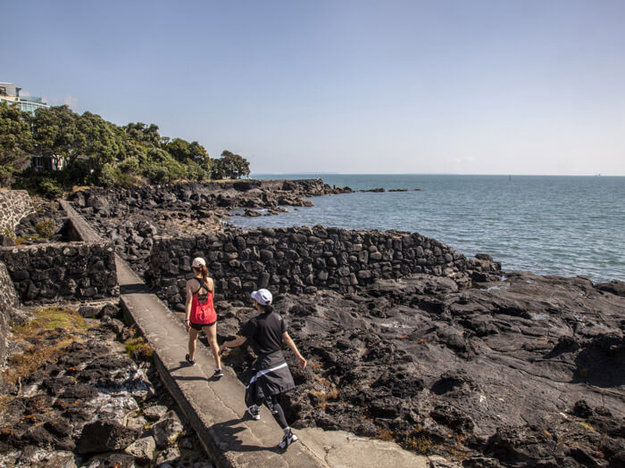
I like that Auckland’s Te Araroa trail mixes up the scenic and salubrious with the city’s more workaday areas. One day, you’re tramping past beachfront cafes thrumming with the mid-morning latte crowd; the next, you’re exchanging greetings with burly security wardens wearing high-viz in the Mangere Bridge pedestrian walkway under the motorway.
Walking Auckland gives you a fresh awareness of its geological claim to fame: it’s the only city in the world built on a basaltic volcanic field that is still active. Yes, active. Every few hundred or thousand years, magma forces its way up towards a weak spot in the Earth’s crust right under Auckland and forms a cone or crater. The most recent eruption, about 600 years ago, produced 6km-wide Rangitoto. You don’t have to wander far to run into vulcanicity: Auckland’s 50 volcanoes are all located within about 20km of the city centre. The Coast to Coast Walkway passes five volcanic sites, including Albert Park, now a green shoulder of the CBD, its volcanic history barely recognisable.

Also on Te Araroa’s volcanic traverse is North Head, with its gun emplacements and military tunnels, built in the late 1880s to protect Auckland from a feared Russian invasion, and upgraded for World War I and II; Auckland’s oldest park, the 75ha Domain, which comprises the remains of the “explosion crater” of the Pukekawa volcano; and Maungawhau and Maungakiekie, with their impressive cones and deep craters.
Fortunately, Auckland’s cones and vents are pocket-sized compared to most of the world’s volcanoes. Still, I’m reminded of the city’s volcanic vulnerability while sitting in the stone “giant’s chair” at Milford Beach, watching the waves lap against the black meringues of ancient lava formed from an eruption at nearby Lake Pupuke some 100,000 years ago. Across the harbour, there’s the distinctive outline of Rangitoto, marking a much more recent blow.
Further south, near Auckland Airport, is the less-visited Otuataua Stonefields Historic Reserve, where early Maori farmers used heat-retaining volcanic stones in the soil to extend the growing season of tropical crops such as kumara and taro. Two centuries ago, Maori were cultivating 8000ha of volcanic stonefields around the Auckland isthmus. Now only 160ha remain.
Read more: Ihumatao and the Otuataua Stonefields: A very special area | The Pouakai Crossing makes a worthy alternative to the Tongariro Crossing
.jpg)
“I didn’t even know this place existed,” I say to my friend as we stroll into Ambury Regional Park, after following the coast around the suburb of Mangere Bridge. Suddenly, we’re among sheep, cows, chickens, goats, ducks and a horse (more specifically, Cameron the draught horse) on this working farm. Lambing, milking, horse riding – city kids can get a real taste of country life in this farm-park on the shores of Manukau Harbour. Lanes between the enclosures allow visitors to get up close to the animals.
And there’s a campsite here for Te Araroa walkers doing it for themselves. The grass is spongy underfoot as I set up my tent for the night; the water is cold and fresh.
Next day, walking on my own now, it’s as if I have the whole of the 9km Mangere Foreshore Track to myself. Even the local birdlife, which is being encouraged to breed here, seems to stay in the thickets. Yet behind the greenery, Watercare’s wastewater treatment plant zaps nearly 400 million litres of Auckland’s sewage every day, pumping the sterile fluids into the harbour on an outgoing tide at the rate of 25 tonnes a second.

From the sounds of airport traffic, the trail makes another turn, this time into Puhinui Reserve and a quiet wetland area tracing the Puhinui Stream. There are rushes and reeds, manuka and cabbage trees, little bridges where I have to duck my head to avoid the abundant foliage. The sound of a New Zealand summer echoes in my ears. But it’s short-lived, going from green space to grey space, where I pop out into Wiri’s industrial centre, with its concrete warehouses. Then the trail dives into a park beside the Puhinui Stream, where I rest my legs.
A pukeko observes from behind a fern frond and, deeming it safe, wanders to the water’s edge for a drink. In its wake a chick follows, a tiny fluffy pompom on two thin sticks. I watch the teaching session until it ends abruptly with the birds scrambling back into the bush at the sound of some kids on bikes.
I think back to the departing words of my isthmus-walking friend. “That’s what I loved about this trail – so many different twists and turns, from one street to the next,” she said. “I’ve seen a different side of Auckland. It’s been fascinating.”

Trail Mix
Katrina Meggett’s urban traverse encompassed five sections of Te Araroa’s greater Auckland region trail: the North Shore Coastal Walk, from Long Bay Regional Park to Devonport (23.5km); the Coast to Coast Walkway, from the Ferry Terminal in the CBD to Onehunga (14km); Onehunga to Puhinui (25km); and the Puhinui Stream Track (9.5km). Her 85km walk also included part of the Totara Park to Mangatawhiri River section (26km in total).
The Te Araroa trail website includes comprehensive, downloadable trail notes and maps. Walkers get a potted history and geography of the areas they’re passing through, as well as detailed information on trail signage, the level of difficulty of the terrain, amenities, local transport and accommodation, with overnighting options leaning to the modest and affordable. Unsurprisingly, there are no camping suggestions for the cross-city 14km stretch, but there are holiday park campsites and cabins on the North Shore, and camping at Ambury Regional Park in the south.
This article was first published in the February 2020 issue of North & South.


