May 24, 2016 etc
Metro arts writer David Larsen loves cycling so much he sold his car. He shares the secrets of riding in Auckland, including five of the city’s best routes.
I feel more or less safe on Auckland’s roads. I cycle everywhere – this is literally the case, I sold my car a couple of months ago – and I mostly take my safety for granted. There is a pinch of pixie dust involved in this. Cycling is one of those annoying activities where feeling unsafe tends to make you unsafe; or to put it another way, panicky cyclists often make poor choices. I do a good line in not thinking too hard about some of the risks I run, not because they’re major risks, but because thinking about them isn’t smart.
But mostly, Auckland is just a good place to ride a bike. Why?
1. Our roads are wide. (I ride in Wellington quite often. I love Wellington. Not for the width of its roads.)
2. The same exact sprawl that makes this city so wonderfully nightmarish for anyone trying to design good mass transit corridors means that anywhere you want to go, there are a dozen different quiet back street routes.
3. We have a huge variety of terrain; you can find flat rides, steep rides, gently rolling rides. (Again, compare Wellington). And of course,
4. We’re increasingly a city of bike lanes. “Increasingly” so far means “here and there and don’t count on it”, but even as things are now, there are a whole bunch of roads I’d once have hesitated to use which are more or less safe for cyclists.
This all presupposes that you know how to ride on roads. I had forgotten, until I thought about those two years of work with my sons, how much you have to know to ride on roads. Mostly it’s things that most adults just do know, because mostly it’s the same stuff you’ve learned by osmosis when you’ve been driving a while – in a nutshell, how to read cars’ body language. That slight tilt to the driver’s head which says they’re about to make the turn they haven’t signaled. That slight slowing down and leftwards drift which says they’re maybe getting near the shop they’re going to park outside, or the driveway they’re going to turn into, or maybe they’re wrong about where they are and they’ll speed up again in five seconds, which will change what that other car behind you does next… all that information you process automatically, which tells you which bit of road is about to be bad to be on.
And then to that you add the things only cyclists pay much attention to, like the difference between two potholes neither of which a car would much notice: one is going to give you a solid jar, so maybe get up off your saddle slightly; the other is going to knock you sideways, so go round it. Can you go round it? No, car too close on one side and parked car on the other. Slow the hell down.
Teaching kids to read cars and read roads is just like teaching them to read books or people: it’s complicated and it takes time, and it’s worth doing.
Teaching kids to read cars and read roads is just like teaching them to read books or people: it’s complicated and it takes time, and it’s worth doing. I love riding, I love seeing families out on the road, and I want to list a few favourite routes you might try. For people with kids who aren’t confident road riders yet, I’ve included a couple of safe suggestions. Work up to the others.
Family beach ride for all ages
Auckland’s newest beach is in Onehunga, it’s only six-months-old and it’s a thing of beauty. Landscaped and well planted, with a shared gravel path winding its way around the shore: small ones on starter bikes can tootle back and forth here under supervision, with a paddle and a picnic any time they want a break. (Well, not any time for the paddle: this is the Manukau, so at low tide it spends 90 minutes or so being pure galoptious mud.)
If you have kids able to deal with slightly more range, take them to Ambury Farm: go to the southern end of the beach – use either the shared path or the cycle lane along Orpheus Drive, behind the beach – and just keep going. This involves a short stretch of riding on Orpheus Drive itself. Adults fore and aft is the ideal formation here. It’s a pretty safe little road, well speed bumped, though be aware that it narrows considerably at the far south end. Just before it merges with Onehunga Harbour Road, swing right onto the shared path – helpfully painted bright red – cross the Sea Scouts car park carefully, and head on round another half kilometre or so of shared path to one of the quiet little treasures of Auckland, Old Mangere Bridge.
You can hang out here with the people fishing off the bridge – always a few, sometimes a crowd – and admire the views up and down the Manukau, or you can ride on around the Mangere Bridge foreshore to Ambury Farm, where horses, sheep, cows, and pigs await you. From Ambury Farm you can ride back to the beach. Or, if you want more and your tires are good for slightly rougher surfaces, take the Watercare Coastal Walkway from the shore behind the farm buildings on around as far as you care to go: to the tidal lagoon, or on to the Puketutu Island causeway. The island itself is mostly private land, but it has an accessible foreshore track leading to a good view of the Manukau Heads, or you can go all the way past Puketutu to the Otuataua Stonefields. The area between the Farm and the Stonefields is one of the best in Auckland for coastal birds of all kinds. Note that for a brief period in Spring, a lot of these birds are nesting. You don’t present a hazard to them if you stay on the track. Some of the swans may decide to present a hazard to you, however, if you seem to be coming too close.
This whole area still feels almost purely rural, despite the fact that an international runway is just out of sight behind the trees.
You’re now most of the way to the airport and you’ve hardly had to use a road; adult riders on their own will have a nice time pushing on beyond the Stonefields along Oruarangi Road and then turning right along Ihumatao Road, which leads to the airport. This whole area still feels almost purely rural, despite the fact that an international runway is just out of sight behind the trees. The roads around the actual airport are insanely dangerous for cyclists, not so much because of the road design as because every other driver thinks they’re about to miss a plane, but a mix of cycle paths and footpaths will get you to the shopping precinct to grab a pie, if you feel you’re due a reward for getting so far. I usually turn round when I see the airport traffic and ride back.
The longer beach ride
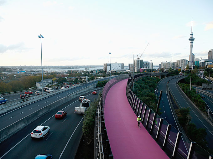
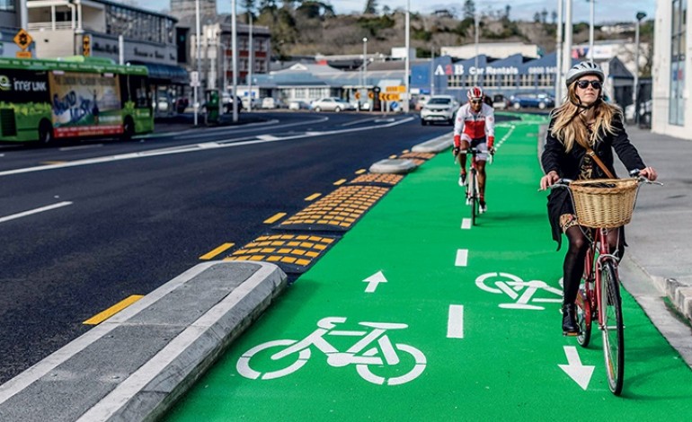 Photo: Auckland Transport.
If you want to start in town and ride out to Onehunga beach, which is fun, or indeed all the way to the airport, here’s an easy route. Let’s say you’re starting at the bottom of Queen Street; perhaps you just got off a ferry. I’m going to pretend you did so I can show you the easiest way up and out of the CBD, which begins with the Beach Road Cycleway. Head one block along Quay Street and then turn right onto Britomart Place. Why look, Beach Road has a cycleway! Follow it to the diagonal bikes-only crossing light. (You may wait a while here. I doubt these lights are the future. Cool though.) (Note, while on the cycleway, that it looks identical to the separate pedestrian walkway off to its side, and is therefore often covered with pedestrians. Attempt to miss them.A bell can be useful in these situations).
I love this cycleway. As sexy as the pink Light Path is, Grafton Gully is at this stage absolutely the best way to get out of central Auckland.
From the crossing, it’s only a little distance to Churchill Street, a quiet little offshoot of Beach Road with a never-terribly-busy shared path, running up to the start of the Grafton Gully cycleway. I love this cycleway. As sexy as the pink Light Path is, Grafton Gully is at this stage absolutely the best way to get out of central Auckland, because, as you’ve just experienced, all its connections are in place. Up you go, snaking around and under Grafton Bridge and on to the very top of Queen Street.
From here there are several options. I actually prefer to use the main roads for this bit: Alex Evans Street across to the top of Symonds Street, Symonds Street to the start of Mt Eden Road, and then direct to the village. For anyone confident with road riding this is easy and quick. Anyone who finds busy traffic scary, stay on the quieter roads. Anyone who hasn’t tried major roads before but feels ready: this is not a bad place to get a feel for it. There are three spots where you need a good understanding of how and when to either occupy your lane or stay out of cars’ way: immediately after the Khyber Pass Road intersection, where the bus lane and the lower of the two car lanes merge, at the base of the Mount Eden reserve where traffic streams in and out of Normanby Road, and just before the village itself, where traffic is often backed up.
Most drivers, amazingly enough, are just people trying not to hit you. It’s much easier for them to manage this if you make it clear what you’re doing and don’t send “pass me” signals when passing would be dangerous.
Sometimes, as when the Symonds Street bus lane abruptly ceases to exist, there isn’t enough space for you to be out of the way: you can either make it clear to the cars behind you that you’re going to be in front of them for the 30 meters to the Mount Eden Road turnoff, or you can cling desperately to the side of the lane and let them find out the hard way that it isn’t wide enough to squeeze past without a high risk of nicking you. This sounds alarming. It isn’t really. Most drivers, amazingly enough, are just people trying not to hit you. It’s much easier for them to manage this if you make it clear what you’re doing and don’t send “pass me” signals when passing would be dangerous.
From the Mount Eden village lights, go straight on a couple of blocks, past the Mobil station, and turn left onto quiet little Disraeli Street. Snake right onto Hasbury Avenue, left onto Windmill Road, and then right again onto St Andrews Road. There are often cars pulling in and out of parks at Windmill Park, just before St Andrews, but St Andrews is the only one of these roads which tends to be busy. It takes you to the lights at Greenlane. You could ride on Greenlane reasonably safely, but it’s fast and busy and not pleasant: instead, immediately after this intersection, go left into Merivale Avenue, a lovely little street with hardly any traffic, and let it take you to The Drive. It’s usually fairly busy – all the East-West options around here are fairly busy – but go right onto it and take it down to Banff Avenue.
 Cycling is one of those activities where feeling unsafe tends to make you unsafe; or to put it another way, panicky cyclists often make poor choices.
Banff takes you across to Manukau Road. This is nearly always busy, and turning right onto it is an exercise in prudence: if you reach the point where you feel tempted to just go for it in one of the not-quite-adequate gaps between cars accelerating away from the nearby intersection with Pah Road, dismount instead, and walk along the footpath to those same lights. Cross there. Get onto Manukau again and ride down the pleasant slope, past Cornwall Park on your left, until you see the Pak’n’Save carpark coming up on your right. You want to turn into Chandler Avenue, as if you were going to that carpark. You’re not. Go past it. Chandler is a dead end, but there’s a walkway through to Crown Street. Use it. Crown Street runs down to Mt Albert Road, which does not have a cycle lane for this stretch and is a nightmare for bikes: you just want to cross it and get onto the footpath, and walk 30 metres down to Erson Avenue. No more busy roads. (If you had stayed on Manukau Road, incidentally, you’d have come to the Royal Oak roundabout. Some people ride through this. I admire them much the way I admire sky divers. It can be done more or less safely if you have nerves of steel, but it isn’t for me.)
Erson Avenue is a tiny little road that takes you round, because Auckland does love to reuse street names, to Symonds Street (no relation). Turn right onto it. Head straight on down to the intersection with Trafalgar Street. This is one of those quiet-looking little streets that happens to collect a fair bit of traffic – you’re closer than you realise to the motorway and locals trying to avoid airport traffic come this way – so cross this one with care. You keep going straight. This is now a steep residential street: great for blasting down at high speed, so long as you keep a very good eye out for people backing out of driveways. At the bottom you turn right into Arthur Street, which is even steeper, and features a speed bump of the unlovely sharp-angles design. Don’t attempt to take this at full speed. Arthur Street ends at a T-junction with Beachcroft Avenue, which is busy, and you really want to have slowed down a good bit before you reach it: even bikes with disc brakes are not going to be able to shed all their Arthur Street momentum in five metres.
Immediately across Beachcroft and just to your left you’ll see a walkway. This leads up to the foot and bike bridge over the motorway. Onehunga Beach is just on the other side. It’s a slightly tricky place to cross Beachcroft, because cars coming from your left are out of sight around the bend, and they come quite fast. Cross with care. You’re at the beach. Good ride.
Mission Bay for ice cream
 Photo: Pexels.
This is such an easy route it’s hardly a route at all, but it’s a damn good ride. Stand at the ferry terminal at Quay Street, facing in towards Queen Street and the city. Turn left. Start riding. Don’t stop until you reach Mission Bay.
Okay, it’s slightly more complicated than that: this route mixes shared paths, which here is a euphemism for “footpath, but we decided putting bikes on it would offend pedestrians less than it would please drivers”, and a few stretches of cycle lane. Loads of parked car hazards (watch out for those abruptly opening doors), loads of traffic, loads of pedestrians. But: one of Auckland’s best sustained stretches of glorious coastal views. Slow, easy riding; always thank the pedestrians who see you coming and duck out of the bike half of what really ought to be pure footpath – it’s nice to be nice! – and be patient with the ones who don’t. There is a Movenpick ice cream parlour in Mission Bay. There is never a bad time for Movenpick.
Takapuna Beach
 Photo: Alice Harbourne.
The reason I’ve started the last couple of routes at the downtown ferry terminal is that bikes travel on ferries for free. This is just amazingly handy. You want a fun day trip? Take your bike to Waiheke. You want a fun multi-day trip? There’s a ferry to the Coromandel. But here’s a neat ride you can knock off much more quickly. Take the ferry to Devonport, and thread your way through the shared paths and back streets to Takapuna.
It’s one of the best little shared path paradises in Auckland: a lovely route across a tidal marsh area.
From the ferry, it’s nice to ride up through the Devonport shops and grab a coffee or a snack. Lots of cafes. Also lots of angle-parked cars, so go carefully. Turn left onto Clarence Street, and follow it up to Calliope Road; I say “up” because the street is dead-end for cars and the connecting walkway will feel near-vertical if you attempt it in a high gear. Calliope runs along to Stanley Bay Park, which is edged by a shared path: take this through to the path round Ngataringa Bay sports field, and from there on around Ngataringa Bay Access Road to Mozeley Avenue. Take that to Victoria Road, and from the end of that drop down (carefully, the path is steep) into Dacre Park and on across Ngataringa Park. Take the shared path next to Lake Road as far as Ngataringa Road, and go up that until you can turn right onto Regent Street. Take Regent as far as Kawerau Ave, and turn left onto that. Turn right onto Merwood Lane. It’s a dead end for cars, but a shared path takes you through to Plymouth Crescent. Turn left, and follow it to Roberts Ave, where you turn left again. Almost immediately, you want to cross over to the cyclepath along the side of Bayswater Park, which you can follow, carefully crossing Bayswater Ave, into one of the best little shared path paradises in Auckland: a lovely route across a tidal marsh area and up, eventually, into Frances Street.
From here you thread your way through the back streets until you rejoin Lake Road just before the major intersection with Esmonde Road: the easiest way is just to take Frances all the way down to Hart Road, turn right, and go all the way along it to Lake Road. Bit of up and down here. Lake Road has a cycle lane; it also has an ungodly quantity of traffic, so you need to adjust your riding mode to hyper-alert, but it’s safe enough. It takes you direct to Takapuna, where one of the best beaches in New Zealand awaits your pleasure. You can get back to the ferry the way you came, or you can take the Lake Road cycle path as far as Winscombe Street, just past Takapuna Grammar, and then thread the coastal back streets all the way to North Head. It’s an easy ride up, and no distance at all back round King Edward Parade to the ferry.
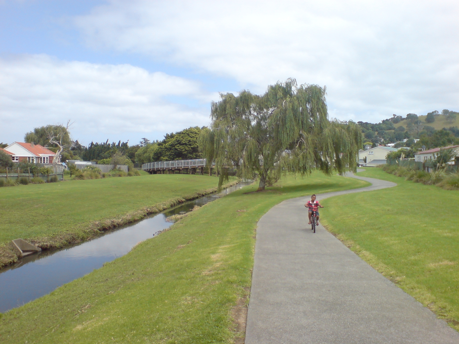
Henderson Creek loop
This is a longer ride, and one of my favourites. It’s a loop, and you can join it at any point. It crosses the Western train line at a couple of points, so if you want to do only part of it, you can drive or ride to the nearest station, take your bike by train – no extra charge – to a point on the loop, and ride a section from there.
Wellingtonians like to tell me Auckland doesn’t have proper hills. Dude, they called it Hillsborough for a reason.
I live in Mangere Bridge, so for me the loop starts just past Onehunga Beach, and involves following Orpheus Drive up to Seacliffe Road, then Frederick Street, and then Carlton Street to reach Hillsborough Road. Carlton Street is the shallowest of the various climbs up from the coast to the Hillsborough ridgeline; if you really want to sweat, go further along Frederick Street to Belfast Street and try climbing that. Wellingtonians like to tell me Auckland doesn’t have proper hills. Dude, they called it Hillsborough for a reason.
Once you’re on Hillsborough Road, you’re co-existing with a major stream of traffic. Mostly the road is double-laned, and at most times of day the lower lane is full of parked cars, which effectively makes it a bike lane: cars can’t fit into it, you can. Keep a good eye out for the dreaded driver side door. But this is a nice road for riding, lots of up and down, occasional sweeping views out over the Manukau. Just keep following it until it executes a short, brutal climb up to where it seamlessly becomes Donovan Street, and follow that to the Blockhouse Bay roundabout (one of those safe-enough roundabouts) and straight through onto Kinross Street. Turn left at the roundabout onto Godley Road, go on round through the Green Bay shops, and then up the longer-than-you-expect-it-to-be hill to Titirangi Road.
This is a major intersection, but an easy enough one: gaps in the traffic are irregularly spaced but frequent. Turn right, and enjoy the downhill. Make no turns until you reach Pleasant Road, which you will turn left onto. It’s another nice, fairly quiet ridge road. (You can spend a lot of energy going up hill and down dale through this area if you stray into side streets; the ridges are your friends.) Ride it as far as Evans Road. Turn left. Steep downhill. Turn right onto Captain Scott Road, and climb carefully up to West Coast Road: you’re in a shopping area here and there are going to be cars pulling in and out of parks. Left onto West Coast, get into the top lane, and almost immediately you’ll see the lights for the turn across the railway line. Make this turn. Now you’re on Glenview Road, but almost as soon as you’re over the tracks, you want to turn left onto Waikumete Road, which skirts the edge of Waikumete Cemetery.
This is a huge old cemetery, full of little roads, and excellent for riding through, which is what you’re going to do. Note that the graves are well tended, and be aware that some of the people you pass here are visiting their dead. That thing you would never do of blasting past pedestrians slightly too close? Really, really don’t do that here. Stay on the left edge of the cemetery: follow Eucalyptus Ave round to Waitakere View Road, and follow it right on round to the cemetery’s far side. Just after you leave the gate you’ll turn left onto Sunnyside Road, and although you pass through one roundabout and one intersection, you won’t be making any more turns for a bit. Just keep going straight. Sunnyside becomes Millibrook Road, Millibrook becomes Vitasovich Avenue. There’s a shared path along a good fraction of this, and you should use it, because the road isn’t as wide as it could be and it’s reasonably busy. Soon it will be very busy, because you’ve reached Henderson.
You’re going to skirt the Henderson Westfield now and nip across Great North Road. The best way to do this: turn left onto Edsel Street, and then right onto Railside Ave. Left onto Stevies Lane, which empties onto Henderson Valley Road, and here I would dismount, walk right to the nearby intersection with Great North Road, and cross at the lights, both ways, so that you end up diagonally opposite. It’s a bastard of an intersection and unless you strike the mythical Moment Of Zero Traffic, there is just no good way to do it on a bike. But this is the only bad spot you have to deal with, because you’ve just reached nirvana: the Henderson Creek path lies before you. The path starts in the car park of the Family Planning Clinic on the corner. This takes you to the car park of the Wave Pool complex, which you need to work your way carefully through, so that you end up skirting between the bolwing club and the pool building. Keep going round behind the pool. On the far side is a little bridge, and once you cross this you’re on the creek path proper: it will take you all the way to the western motorway cycle-way, which has recently been done up and makes for a very nice, straight ride back in towards town.
 Cycling in Underwood Park. Photo: Wikipedia Commons.
Anyone who wants to go all the way into town can just stay on the cycleway until it comes out at Newton Road, and then go on along Ian McKinnon Drive to the top of Queen Street. But I promised you a loop; and what I do is ride the motorway path in as far as Unitec, and then turn onto Carrington Road. (Busy, but has good cyclepath). Turn right onto Woodward Street, which is one of those tricky little streets that’s a little busier than you expect it to be, and cross the railway line and New North Road into Richardson Road. Be careful making this crossing; when the lights go green the cars go mad, and the first 10 meters of Richardson are a bottleneck: if there are any parked cars all, traffic can’t pass you easily, and it’s going to want to. My solution to this is just to sprint. Follow Richardson on past the next set of lights.
Almost immediately, you’ll see a path leading off into Underwood Park. That’s your route. This shared path winds you around as far as Sandringham Road, though you do have to cross Beagle Avenue on the way. (Cars always come down the hill a bit too fast. Be wary.) Turn right onto Sandringham and go straight to the lights, and straight on. This appears to be a dead end with big box stores to left and right. Behind the one on the left, there’s a path leading to a bridge over the motorway, and if you turn left on the far side, you’re on a shared path which will take you all the way to Dominion Road. Cross that, and the path continues around Keith Hey Park and on to Hillsborough Road where this loop began: and then, if you’re me, you cross over at the lights, take the curving shared path leading up the hill, and come to Hendry Avenue, which drops precipitously down towards the roundabout at Queenstown Road – not really safe, too much impatient motorway traffic, I go up the footpath a little and cross at a distance from it – and then on down to Onehunga Beach.
Which is where the first of these routes began, and a good place to finish.
Metro loves cycling, which is why we’re proud supporters of the NZTA’s Share the Road campaign. Read more here.